
Frankenstorm is the term used to describe the convergence of 3 storm systems with Hurricane Sandy barrelling up from the Atlantic ocean being one of them.
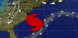
A blocking high pressure system over the Maritimes will make the jet stream dip down and pull Sandy into Ontario. Since it is a slow moving storm, it is projected to dump alot of rain across the Eastern U.S. and into Canada. As of Friday, the landfall targets are somewhere between Ocean City, Maryland and New York with a jet stream pattern pulling the storm in a north-westerly direction.
Preparation are underway across the entire eastern seaboard for the approaching storm. The problem is when storms converge. This can create the “perfect storm” for heavy rain and flooding, downed power lines and trees and other havoc. There is no reason to panick, but preparation is key to weathering the storm, especially for east coast residents of the U.S. when Sandy arrives on Monday or Tuesday.
This could be a very wet Halloween!
Stay Safe and Dry!


